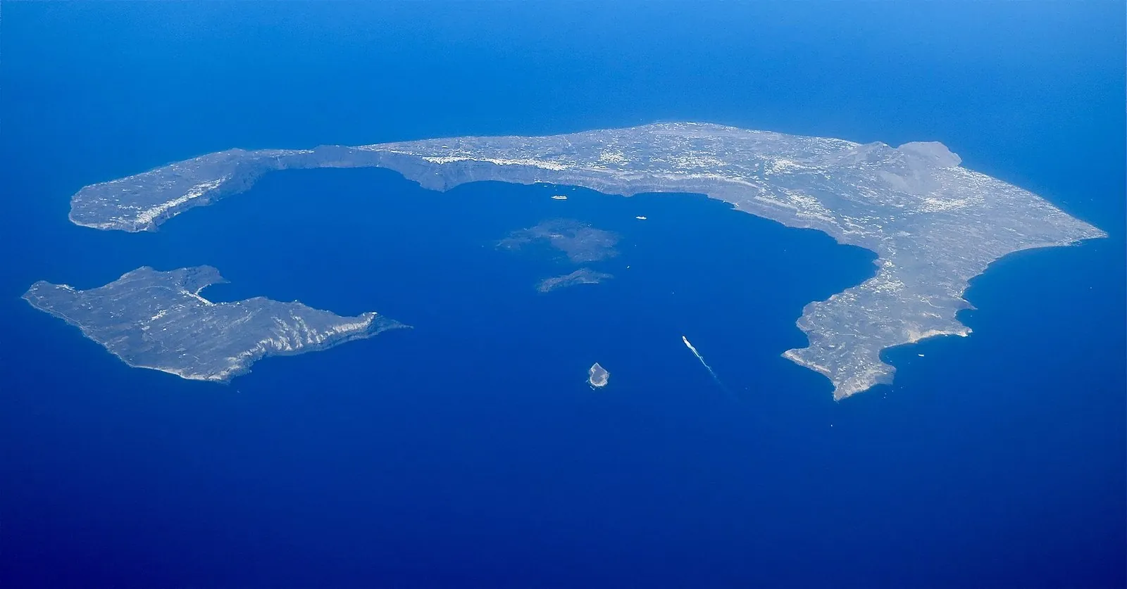
Every hotel terrace on the caldera looks into the same thing: the flooded crater of the Santorini volcano. The island isn’t near a volcano or built on top of one; it is one, a ring of cliffs left standing after a series of enormous eruptions, with an active vent still smoking quietly on the dark islands in the middle of the bay. The volcano last erupted in 1950, a burst of unrest in 2025 put it back in the news, and precautions stay in force until March 31, 2027. The practical decision for you is simple: see it up close by boat, walk the crater on Nea Kameni, then read its layers in the cliffs from the rim.
Quick answer: Santorini is an active volcanic complex in the Hellenic Volcanic Arc, formed by overlapping volcanoes and at least four caldera collapses, the latest in the Minoan eruption around 1600 BC. Its most recent eruption was on Nea Kameni from January 10 to February 2, 1950. You can visit the crater by boat; the volcano ticket is EUR 5 in cash (2026).
Last updated October 9, 2026. We built the eruption history from the Smithsonian Institution’s Global Volcanism Program, and the account of the 2025 unrest from peer-reviewed studies and Greek Civil Protection decisions, checked between September 24 and October 1, 2026. We aren’t volcanologists; where scientists still disagree or the evidence is new, we say so, and nothing here replaces official safety notices on the island.
- What changed: early 2025 brought weeks of earthquakes between Santorini and Amorgos and a state of emergency from February 5, 2025. Later studies tied the swarm to magma intruding from beneath Kolumbo, the submarine volcano to the northeast. There was no eruption.
- Now: after a new earthquake sequence in 2026, Civil Protection measures in force until March 31, 2027 close the road and shore path at Ammoudi, control traffic at Athinios port and create a restricted zone at Fira’s Old Port. The cable car and the Old Port footpath are not restricted.
- What it costs: the Nea Kameni volcano ticket is EUR 5 a person, cash, and usually not included in tour prices; classic wooden-boat volcano tours start at EUR 30 (operator’s site, October 2026).
- The trap: most catamaran cruises swim near the volcano but don’t land on it. If you want to stand in the crater, book a volcano boat.
- Safety: in any emergency in Greece, call 112; the measures can be tightened at short notice if strong earthquakes return.
On this page: Volcano facts | Is Santorini a volcano? | Location and map | How the caldera formed | The Minoan eruption | Eruption timeline | Kolumbo | Is it active? | The 2026 measures | Monitoring | Volcano landscapes | How to visit | Places to see the volcano | Safety | FAQ
Santorini Volcano Facts at a Glance
| Question | Answer |
|---|---|
| What kind of volcano? | A complex of overlapping shield volcanoes, cut by at least four calderas, with lava domes in the middle (Smithsonian Global Volcanism Program) |
| Where? | The southern Cyclades, in the Hellenic Volcanic Arc above a subduction zone; the GVP’s reference point is 36.404°N, 25.396°E |
| Calderas | About 180,000, 70,000, 21,000 and 3,600 years ago, the last in the Minoan eruption |
| Biggest eruption | The Minoan eruption, around 1600 BC; one widely cited radiocarbon study dates it to 1627-1600 BC |
| Eruptions since then | Nine eruptive periods from 197 BC to 1950 built Palea Kameni and Nea Kameni |
| Last eruption | January 10 to February 2, 1950, on Nea Kameni |
| Neighbor | Kolumbo submarine volcano, 5 to 23.5 km northeast; erupted violently in 1650 |
| Recent unrest | Caldera inflation from mid-2024, an earthquake swarm and magma intrusion in early 2025, no eruption |
| Current measures | Civil Protection restrictions at Ammoudi, Athinios and Fira’s Old Port until March 31, 2027 |
| Visiting | By boat to Nea Kameni; EUR 5 cash ticket; volcano tours from EUR 30 (October 2026) |
A few Santorini volcano facts surprise almost everyone: the famous cliffs are the inside wall of a collapsed volcano; the island’s dark beaches are made of volcanic sand and pebbles; the two black islands in the bay are less than 2,300 years old, younger than the Royal Stoa at Ancient Thera; and the island’s richest farmland is volcanic ash, which is why Santorini grows grapes and tomatoes with almost no rain.
Is Santorini a Volcano? Is It Built on One?
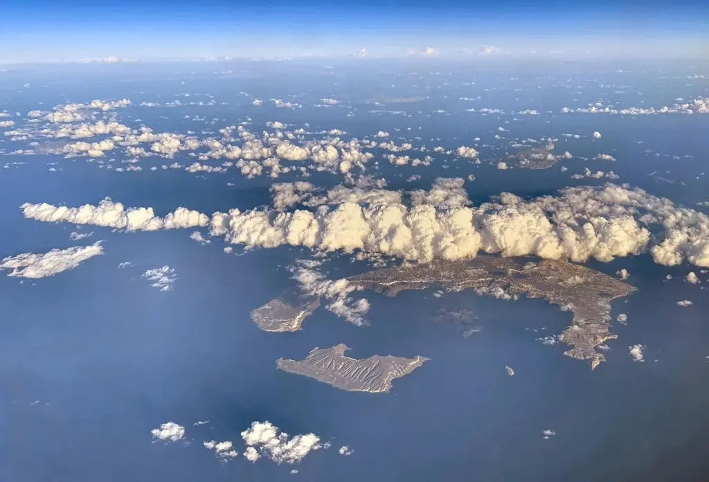
Yes, and yes. Santorini, along with Thirasia and the islet of Aspronisi, is what’s left of a volcanic island that has been built up and blown apart several times. The Smithsonian’s Global Volcanism Program describes it as overlapping shield volcanoes cut by at least four partly overlapping calderas, the bowl-shaped depressions that form when a volcano empties its magma chamber in a huge eruption and the ground above collapses into it. The sea has flooded the latest of those bowls, which is why Fira, Imerovigli and Oia sit on the rim looking down a cliff hundreds of meters high to the water.
So when people ask whether Santorini is built on a volcano, the more accurate answer is that the villages on the west side are built on its broken rim, and the beach towns on the east side sit on its gentler outer slopes. VolcanoDiscovery describes about two million years of volcanic activity piled around a small non-volcanic core, the old rock you can see in the mountain of Profitis Ilias and the ridge of Ancient Thera. Everything else, from the black sand of Perissa to the pumice in the vineyards, came out of the volcano.
Is it active? Volcanologists class Santorini as an active volcano because it has erupted in historical times and still shows signs of life: hot gases escape from vents in the Nea Kameni crater, the water at the Palea Kameni springs is warmed and colored by volcanic activity, and the ground moved measurably in 2024 and 2025. Active doesn’t mean erupting. The volcano has been quiet on the surface since 1950, and the island lives with it the way Naples lives with Vesuvius: carefully, and with scientists watching.
Where Is the Santorini Volcano? Location and Map
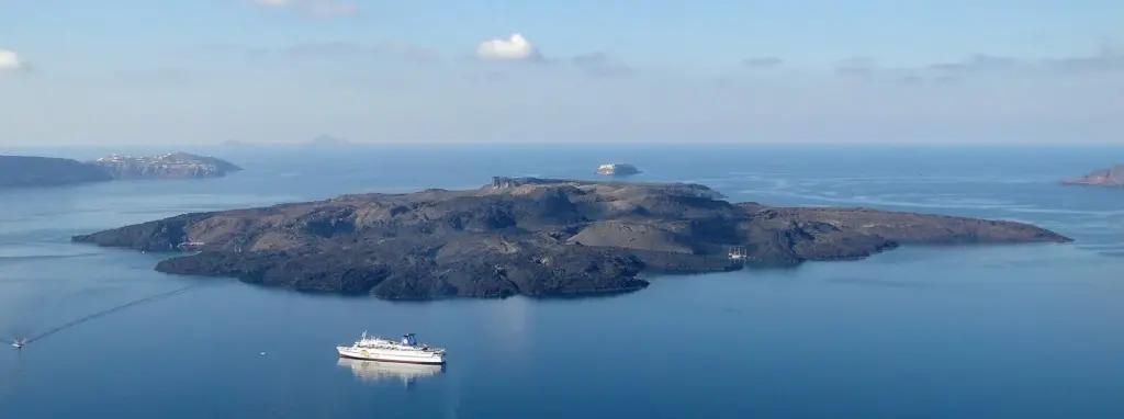
The Santorini volcano is in Greece, at the southern edge of the Cyclades in the Aegean Sea, part of the Hellenic Volcanic Arc that also includes Milos, Nisyros and the Methana peninsula. The arc exists because the African plate is sliding beneath the Aegean, and the GVP lists Santorini’s setting as a subduction zone on continental crust. The volcano’s active heart is Nea Kameni, in the middle of the caldera, a short boat ride from Fira’s Old Port.
Use the map to fix three landmarks. Nea Kameni, the larger dark island in the middle, holds the crater you can walk. Palea Kameni, the smaller one to its southwest, has the hot springs. And Kolumbo, the submarine volcano that caused the 2025 headlines, lies off the map to the northeast, under the sea beyond Oia and Cape Columbo.
How the Santorini Caldera Formed
The Santorini caldera wasn’t made in one blast. The GVP describes at least four collapses over almost 200,000 years: an old southern caldera about 180,000 years ago, the Skaros caldera about 70,000 years ago, the Cape Riva caldera about 21,000 years ago, and the youngest, about 3,600 years ago, in the Minoan eruption. Each time, a huge explosive eruption emptied the magma chamber, the roof of the volcano collapsed, and the sea poured in. Between collapses, new volcanoes grew in the gap, only to be blown apart again.
You can read that history in the caldera wall. Stand on the path between Fira and Imerovigli and look across or down: the cliffs are banded in black, red, brown and cream. The dark layers are mostly lava flows from volcanoes that once filled the bay; the reds are oxidized ash and scoria; the pale bands near the top are pumice and ash from the great explosive eruptions, the Minoan one included. Skaros rock, below Imerovigli, is a remnant of one of those older volcanoes, which the GVP lists as a shield volcano in its own right.
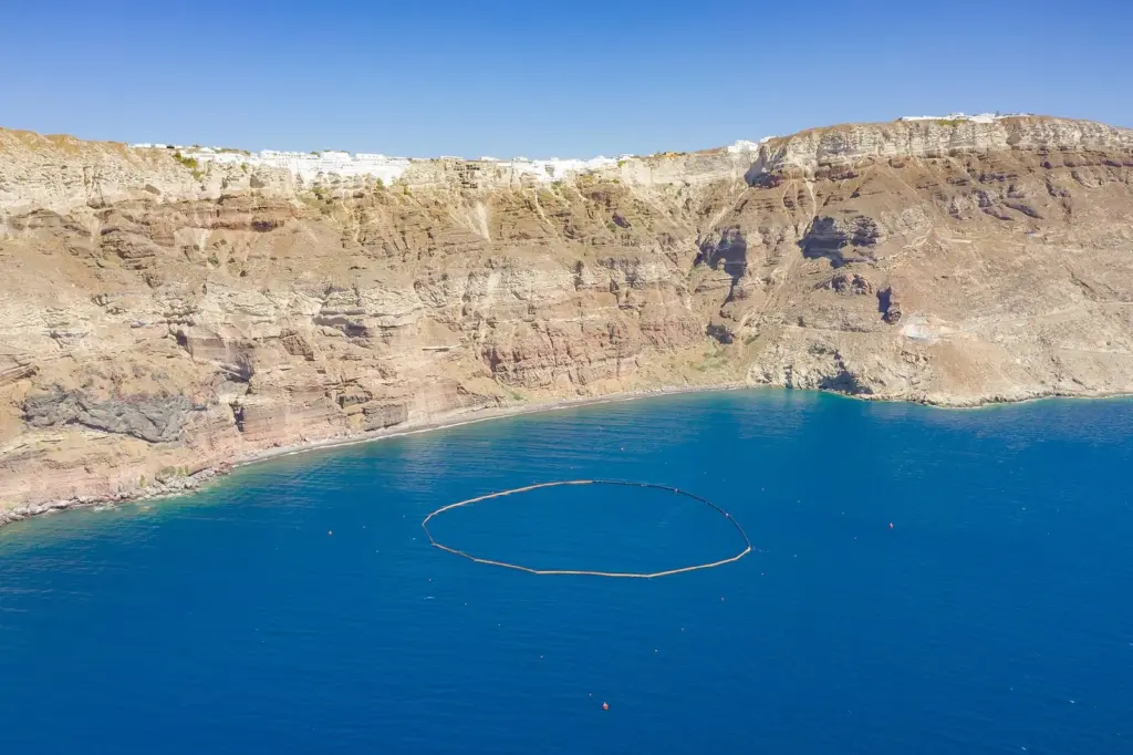
Santorini caldera formation is still an active field of research, and the details keep changing as scientists map the seafloor and date the layers. What doesn’t change is the big picture: the bay is the volcano, the cliffs are its sliced-open flank, and the islands in the middle are the volcano rebuilding itself.
The Minoan Eruption: What Destroyed Santorini 3,600 Years Ago?
The eruption that gave the caldera its present shape happened in the Late Bronze Age, when Akrotiri on the south coast was one of the busiest towns in the Aegean. The Hellenic Ministry of Culture’s account is that strong earthquakes drove the townspeople out in the last quarter of the 17th century BC, and the eruption followed, burying the island and the town under ash. The GVP puts it at about 3,600 years ago, around 1600 BC. A widely cited radiocarbon study published in Science in 2006, by Walter Friedrich and colleagues, dated an olive branch buried in the eruption to 1627-1600 BC; archaeologists working from Egyptian and Cretan chronologies have long argued for a later date, and the debate continues.
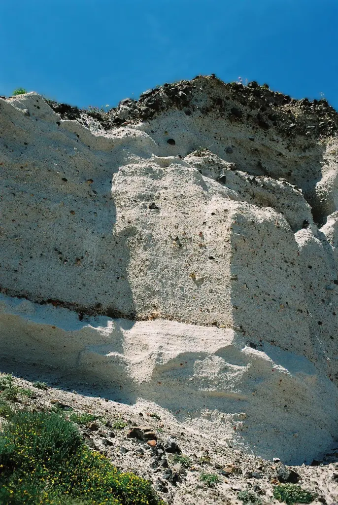
The scale was enormous. Oregon State University’s Volcano World puts the erupted magma at about 30 cubic kilometers, with an eruption column climbing some 36 km in its first phase, and ranks it among the largest eruptions of the past 10,000 years. Pumice and ash blanketed Santorini dozens of meters deep in places, which is why the excavation at Akrotiri still sits in a pit below the modern ground. Ash fell across the eastern Mediterranean, and tsunamis reached neighboring coasts.
What it did to the wider Bronze Age world, and whether it inspired Plato’s Atlantis, is a question for historians as much as volcanologists; our guide to Santorini history covers Akrotiri, the Atlantis debate and how the island recovered. For the volcano, the key point is simpler: the Minoan eruption hollowed out the bay that defines Santorini today, and every eruption since has happened inside it.
Santorini Volcano Eruptions: A Timeline Since 197 BC
After the Minoan eruption, the volcano went quiet for well over a thousand years. Then, from 197 BC, a long series of smaller eruptions began building new land in the middle of the caldera. The Smithsonian’s Global Volcanism Program lists these confirmed eruptive periods, each measured on the Volcanic Explosivity Index (VEI), a scale where 2 is a modest eruption and the Minoan event sits near the top.
| Dates | Where | VEI | What it built |
|---|---|---|---|
| 197 BC | Hiera island | 3 | The first new island in the caldera after the Minoan eruption |
| 46 AD | Palea Kameni | Not given | The “old burnt island”, today home to the hot springs |
| About July 726 | Northeast side of Palea Kameni | 4 (queried) | The most explosive post-Minoan eruption on record |
| 1570-1573 | Mikri Kameni | 3 | A small island later joined to Nea Kameni |
| May 23, 1707 to September 14, 1711 | Nea Kameni | 3 | The birth of the “new burnt island” |
| January 26, 1866 to October 15, 1870 | Georgios, Afroessa and Reka domes | 2 | New lava domes on Nea Kameni; fatalities recorded |
| August 11, 1925 to May 1926, with activity to 1928 | Dafni dome | 2 | Joined Mikri Kameni to Nea Kameni |
| August 20, 1939 to July 2, 1941 | Triton, Ktenas and Fouque domes | 2 | Further domes and flows on Nea Kameni |
| January 10 to February 2, 1950 | Liatsikas dome | 2 | A small lava dome and flow with explosive activity: the latest eruption |
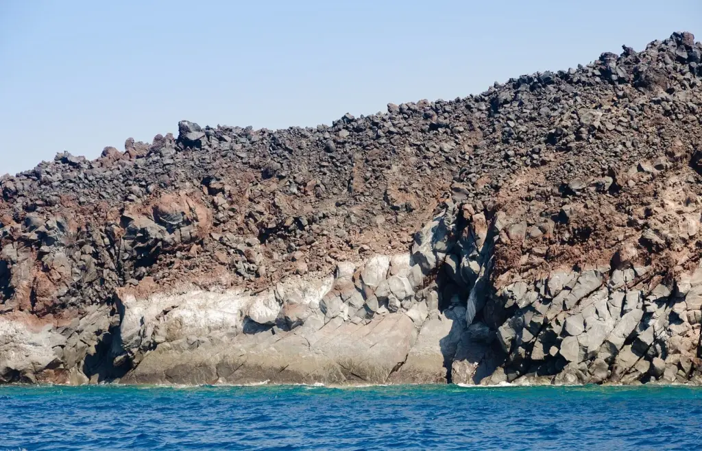
Three things stand out. The eruptions have grown the Kameni islands step by step, so the dark island you walk on is literally made of these events. They’ve been modest compared with the Minoan eruption, mostly slow outpourings of thick lava with explosive bursts. And they’ve come at irregular intervals, from decades to centuries apart, which is why scientists watch the volcano continuously rather than waiting for a pattern.
The 1866-1870 eruption also changed how the world saw Santorini. The French geologist Ferdinand Fouqué studied it, and his 1879 book on Santorini and its eruptions is still cited in the GVP’s reference list. Each Santorini volcano eruption since then has been watched more closely than the one before.
Kolumbo: The Submarine Volcano Next Door
Santorini has a neighbor that most visitors never see. The Kolumbo volcano lies under the sea northeast of the island, part of a volcanic field that a 2025 review in the Bulletin of Volcanology places 5 to 23.5 km northeast of Santorini, with at least 25 small submarine cones and one larger central volcano.
In 1650 that central volcano erupted violently, a VEI 5 explosive eruption by the review’s reckoning, bigger than anything at Santorini since the Bronze Age. It produced tsunamis, ash falls and lethal clouds of gas that drifted over Santorini and killed people on the island; the review notes accounts of about 50 deaths, and other sources give higher figures. Scientists have since imaged a magma chamber 2 to 4 km beneath the crater and a hydrothermal system venting carbon-dioxide-rich fluids on the crater floor.
Kolumbo matters to visitors today because it turned out to be central to the 2025 unrest. The best current science, described below, suggests that the magma which intruded beneath the sea in early 2025 came from a reservoir under Kolumbo, and that Santorini’s and Kolumbo’s plumbing may be linked more closely than once thought. There’s nothing to see of it from the surface, but it’s a big reason the monitoring network extends well beyond the caldera.
Is the Santorini Volcano Active? The 2025 Unrest Explained
In late January 2025 an intense earthquake swarm began in the sea between Santorini and Amorgos and continued for about six weeks. Greece declared a state of emergency for Santorini on February 5, 2025, schools closed, and more than 10,000 people left the island. The largest earthquakes were around magnitude 5, and total counts vary widely by method, from about 1,200 to tens of thousands, so be wary of anyone quoting a single precise number. The Akrotiri archaeological site closed for safety inspections and reopened on April 11, 2025. There was no eruption.
The first explanations leaned toward tectonic faulting along the Anydros and Amorgos fault zone. Later peer-reviewed work painted a more volcanic picture. A study in Nature in 2025 described a coupled magma system linking Santorini and Kolumbo, and research published in Science reconstructed the sequence in detail: the Santorini caldera had been gently inflating since mid-2024; in January 2025 a sheet of magma, a dike, pushed out from a reservoir in the middle crust beneath Kolumbo and traveled horizontally about 30 km; and roughly 25,000 earthquakes, precisely relocated, traced its path over two months. The magma stalled underground.
Research based on regional satellite positioning (GNSS) measurements reports that the unrest ended in late December 2025. That’s reassuring, but it isn’t the end of the story. A new earthquake sequence in early to mid-2026, with reported magnitudes of roughly 3.5 to 5.1, led Greece’s Standing Scientific Committee for Seismic Risk Assessment to recommend fresh precautions, which the government adopted in April 2026.
So is the Santorini volcano active? Yes, in the scientific sense: it has a living magma system, it has erupted in modern times, and it showed real unrest in 2024 and 2025. Is it about to erupt? No official statement has predicted an eruption, and the official response has been targeted precautions rather than closing the island. The honest position for a visitor is the one the authorities take: go, enjoy it, follow local notices, and know what to do in an earthquake.
The 2026 Measures and What They Mean for You
The Joint Ministerial Decision adopted in April 2026 is in force until March 31, 2027, and Euronews’ report of it notes that the measures can be changed or suspended immediately if strong earthquakes or extreme weather occur. What it covers:
- Athinios port: traffic control during ship arrivals and departures to reduce congestion and the time vehicles spend in the port area.
- Ammoudi: the road from the Oia ring road down to Ammoudi port is closed to vehicles, except supply vehicles from 05:00 to 10:00, municipal shuttles carrying visitors in rotation, and traffic for Thirasia. People can still reach and stay in Ammoudi, including from the sea.
- Ammoudi to Agios Nikolaos path: the shore path is closed.
- Fira’s Old Port: a restricted zone bars visitors from the Old Port area and the upper slopes around it. The cable car and the footpath between Fira and the Old Port are not restricted, and volcano boat operators still list Old Port departures.
For most visitors, the practical effect is small: allow more time at Athinios, plan how you’ll get down to Ammoudi, and expect parts of the Old Port and some cliff-foot areas to be fenced off. Separately, rockfalls during the 2025 swarm reinforced the long-standing closure of the cliff path to Red Beach, which is reached only by boat, and hit the slope of Skaros rock, so check locally before heading out to it. Respect fences and signs at the foot of cliffs: in an earthquake country, the danger comes from falling rock far more often than from the volcano itself.
How Scientists Watch the Santorini Volcano
Santorini is one of the most closely studied volcanoes in Europe, and the 2025 unrest is a good example of why that matters. Long before anyone on the island felt an earthquake, instruments had picked up the slow swelling of the caldera that began in mid-2024. When the swarm came, the same networks let researchers relocate roughly 25,000 earthquakes and map where the magma was going underground.
The tools are worth knowing, because news reports mention them constantly:
- Seismometers on the island and the surrounding islands record every tremor. The pattern of small earthquakes, how deep they are and how they move, shows where rock is breaking and where fluids or magma are pushing.
- GNSS stations, the scientific cousins of the GPS in your phone, measure ground movement to fractions of a centimeter. A caldera that rises and spreads outward is usually filling with magma or hot fluids below; one that sinks back is relaxing. GNSS data is also what researchers used to report that the 2025 unrest ended in late December 2025.
- Satellite radar compares images taken weeks apart to map how the whole island deforms, without anyone climbing a slope. Researchers have published time series of this data covering Santorini from 2023 to 2025.
- Gas and temperature measurements at the Nea Kameni fumaroles and in the sea show whether the hydrothermal system is heating up or giving off more carbon dioxide.
- Seafloor studies at Kolumbo, where researchers have imaged a magma chamber 2 to 4 km down and active hydrothermal vents on the crater floor, extend the watch beyond the caldera.
On the Greek side, monitoring brings together the National Observatory of Athens, university research groups and a dedicated Institute for the Study and Monitoring of the Santorini Volcano, whose 1996 guide to the volcano still appears in the Smithsonian’s reference list. Their findings go to scientific committees, and in 2026 it was the Standing Scientific Committee for Seismic Risk Assessment whose recommendations led to the current Civil Protection measures. As a visitor you’ll never see most of this work, but it’s the reason decisions about the island are made on evidence rather than rumor.
The Volcano in the Landscape: Beaches, Cliffs and Vineyards
Once you know what to look for, the volcano is everywhere on Santorini, not just in the caldera. Santorini geology shapes the colors of the beaches, the texture of the roads and the taste of the wine.
- Black-sand beaches. Kamari, Perissa and Perivolos owe their dark sand and pebbles to volcanic rock ground down by the sea. The sand gets hot enough in summer that you’ll want shoes for the walk to the water.
- Red and white beaches. Near Akrotiri, Red Beach sits under cliffs of iron-rich volcanic rock, while nearby White Beach is backed by pale cliffs of ash and pumice. Both are reached by boat, and the red cliffs have been closed to walkers since 2013 because of rockfalls.
- Pumice cliffs. Along the south coast and around Akrotiri, thick pale layers of pumice and ash, laid down by the great explosive eruptions, stand in cliffs carved by wind and waves. They’re soft, which is why islanders could dig cave houses and wine cellars into them, and why they crumble.
- The caldera wall. The banded cliffs below Fira, Imerovigli and Oia are a cross-section through the volcano’s older lavas and ash layers, a geology lesson you can read from your breakfast table.
- Vineyards and gardens. The island’s farmland is volcanic ash and pumice that holds little water, which is why Santorini’s vines are trained low in kouloura baskets against the wind and why its fava and cherry tomatoes, both protected EU products, are so small and concentrated.
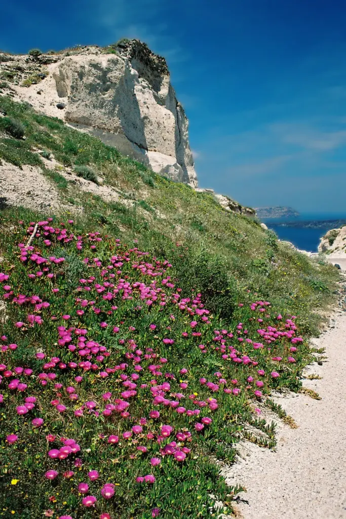
Seen this way, a day at the beach and a winery afternoon are both volcano trips. The difference from Nea Kameni is that here the volcano has had a few thousand years to cool down, weather and grow grapes.
The Volcano Underwater: Diving the Caldera
Below the waterline, the volcano is just as dramatic as the cliffs above it. Dive centers on the island run trips along the volcanic shoreline, and one of them, Navy’s Waterworld in Kamari, says it uses more than 42 dive sites, reached by boat or by truck. It describes visibility of 20 to 30 meters through the year, water temperatures from about 19°C in May to 25 or 26°C in July and August, no tides and almost no currents, with the south coast usually the most sheltered when the summer meltemi blows from the north.
Santorini Dive Center runs its dives from a station at Caldera Beach in Akrotiri, with daily two-tank trips to sites around the caldera and the volcano for certified divers. Expect lava formations, walls, caves and drop-offs rather than coral reefs. For beginners, try-dives start in shallow water off the beach; for experienced divers, the caldera walls are the closest you’ll get to swimming down the inside of a volcano. Our guide to boat tours and water activities lists the dive centers and their prices.
Living With the Volcano
Santorini has always lived with its volcano, and with earthquakes from the faults around it. The 1956 earthquake, a tectonic event centered near Amorgos rather than an eruption, wrecked much of the caldera villages and emptied the island for a generation. The 1950 eruption on Nea Kameni, six years earlier, was small by comparison.
The 2025 crisis tested the island in a new way. When the state of emergency was declared on February 5, 2025, schools closed and more than 10,000 people left the island. Within months, the earthquakes eased, Akrotiri reopened on April 11, 2025, and the season went ahead. The 2026 measures are the island’s way of keeping that balance: specific, limited restrictions on the places most exposed to rockfall and congestion, rather than closing the island.
The islanders also celebrate the volcano. The Ifestia festival re-creates an eruption with fireworks over the caldera; the 2026 edition was held on September 19, and the 2027 date hasn’t been announced. It’s a reminder that, on Santorini, the volcano isn’t only a hazard. It’s the reason the island looks the way it does, the reason its wine tastes the way it does, and the reason you’re probably here.
The Other Pieces of the Rim: Thirasia, Aspronisi and the Northern Cones
Santorini’s crescent is only part of the old volcano. Across the caldera to the west, Thirasia is the largest surviving piece of the western rim, with its own villages, a harbor and the same layered cliffs facing inward. In the gap between Thirasia and the island’s southern tip sits Aspronisi, “the white island”, a tiny islet the Smithsonian lists as a tuff ring, made of compacted volcanic ash. Together the three pieces trace the outline of the island that stood here before the Minoan eruption broke it open.
On the main island, the volcano’s older vents are easy to miss because they look like ordinary hills. The GVP’s list of features includes the cinder cones of Megalo Vouno (329 m) and Kokkino Vouno, the “red mountain” (292 m), in the island’s north on the way to Oia, along with Skaros and the Peristeria shield volcano. Drive or walk the north of the island and the reddish, rounded hills you pass are volcanoes too, just much older than Nea Kameni. Thirasia itself, quiet and little visited, deserves a day of its own; the three-island boat trips give you about two hours there.
Seeing and Photographing the Volcano From the Villages
The caldera villages all face west across the water, which shapes how the volcano looks through the day. In the morning, the sun rises behind you and lights the Kameni islands and the inner cliffs of Thirasia head-on, so you see the texture of the lava, the old domes and the boats at the landing. That’s the time for detailed photographs and for understanding what you’re looking at. In the late afternoon and at sunset, the islands turn into dark silhouettes against bright sea and sky: less detail, more drama.
- Fira and Firostefani: the closest view of Nea Kameni and the volcano boats crossing from the Old Port; the caldera path between them is the classic vantage point.
- Imerovigli: the highest of the rim villages, with Skaros rock in the foreground and the whole southern caldera beyond.
- Oia: the view down the length of the caldera from its northern tip, with Thirasia close across the strait.
- From the water: a boat gives you the caldera wall from below, the layers of older volcanoes rising hundreds of meters over your head, which no photograph from the rim can match.
Best Time for a Volcano Trip
The volcano boats and most catamarans run from spring to October, with the most departures from June to September. Two choices make the biggest difference to the experience:
- Go in the morning. Morning boats beat the heat on Nea Kameni’s shadeless path, and the water at the hot springs is usually calmer before the afternoon wind picks up.
- Go in the shoulder months if you can. In late spring and early autumn the crater walk is far more comfortable than in July and August, the light is softer, and boats are less crowded.
If you want to see more than the volcano, Santorini Excursions’ three-island trip (EUR 35 without transfer in October 2026) adds about two hours on Thirasia, the quiet island across the caldera, and sails home under the cliffs of Oia. Cruise passengers can join Old Port departures by taking the cable car down (EUR 10 an adult each way on the 2026 price list), but should leave a wide margin to get back to the ship. Whatever you book, keep a day spare in case wind cancels the trip.
Volcano Words, Explained
- Caldera: a large bowl-shaped depression formed when a volcano empties its magma chamber and the ground above collapses. Santorini’s is flooded by the sea.
- Dike: a vertical sheet of magma that forces its way through rock. The 2025 unrest is explained by a dike that traveled about 30 km underground without reaching the surface.
- Fumarole: a vent that releases volcanic gases and steam. You’ll find them in the Nea Kameni craters.
- Lava dome: a mound of thick, slow-moving lava piled up around a vent. Nea Kameni is built largely of them, each named for its eruption.
- Pumice: light, frothy volcanic rock full of gas bubbles, light enough to float. It forms the pale layers in the cliffs.
- VEI (Volcanic Explosivity Index): a scale for the size of explosive eruptions. Santorini’s 20th-century eruptions were VEI 2; Kolumbo’s 1650 eruption was VEI 5.
- Swarm: a burst of many earthquakes in one area without a single clear main shock, like the one in early 2025.
- GNSS: satellite positioning (including GPS) used to measure tiny movements of the ground.
How to Visit the Santorini Volcano
The only way onto the volcano is by boat. The classic trip is a wooden-boat volcano tour from Fira’s Old Port or Athinios. Dakoutros Bros, which runs these boats under the Santorini Excursions name, lists departures at 11:00 and 14:30 from the Old Port and 10:30 from Athinios for EUR 30 without transfer, with a crossing of about 10 minutes from the Old Port and 20 from Athinios. You get about an hour and 15 minutes on Nea Kameni, with an optional walk up to the crater, then about 30 minutes at the Palea Kameni hot springs. Food, drinks and the volcano ticket aren’t included.
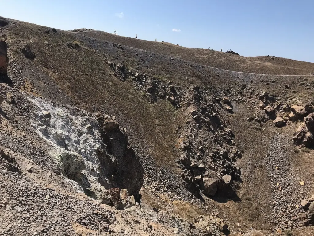
On Nea Kameni. The ticket is EUR 5 a person, in cash, according to the operator. From the landing, a rough path of cinders and lava blocks climbs to the summit craters, with no shade on the way. Along the way you’ll pass the lava of each eruption, from the 18th century to 1950, and near the top you may smell sulfur and see wisps of gas from fumaroles. Wear real shoes, carry water, and skip it in the midday heat of high summer if you can; the morning boats are cooler and calmer.
At the hot springs. Boats anchor off Palea Kameni and you swim the last stretch, about 30 meters according to the operator, into an inlet where the water turns rust-orange from iron. Don’t expect a hot bath: the operator puts the water at 20 to 25°C, warmer than the sea in spring and autumn but not by much in high summer. Wear dark swimwear you don’t mind staining, and know that non-swimmers can’t make the swim on these boats.
Catamarans are different. Most catamaran cruises swim near the volcano and stop at the hot springs, but two operators say plainly that their trips don’t land on Nea Kameni. If the crater walk is the point, book a volcano boat; if swimming, food and wine are the point, book a catamaran and see the crater from the deck. Our guide to every Santorini boat tour compares the options, prices and departure ports.
Six Places to See the Santorini Volcano
You don’t have to set foot on Nea Kameni to understand the volcano. These are the places where it shows itself most clearly, on land and at sea.
1. Nea Kameni Crater
The active heart of the volcano, by boat only. Built almost entirely since 1707, Nea Kameni is where the 1950 eruption happened and where fumaroles still steam. The summit path takes you across lava from successive eruptions to the craters, with the whole caldera ring around you. Plan it: volcano boats from the Old Port or Athinios from EUR 30 (October 2026), plus the EUR 5 cash ticket; about 1 hour 15 minutes ashore. Best for: anyone who wants to stand inside a volcano.
2. Palea Kameni Hot Springs
A swim in volcano-warmed water. The older Kameni island formed in 46 AD; its warm, iron-stained springs sit in a narrow inlet by a tiny white chapel. Santorini hot springs are more about the color and the setting than the temperature. Plan it: included as a swim stop on volcano boats and most catamarans; a 30-meter swim from the boat; dark swimwear. Best for: confident swimmers who want the full volcano experience.
3. The Caldera Rim Path
The volcano’s sliced-open wall, from above. The walk from Fira to Firostefani and Imerovigli follows the top of the caldera wall, with the layered cliffs below you and the Kameni islands straight ahead. It’s free, and it’s the best way to grasp the size of the collapse. Plan it: about 15 minutes from Fira to Firostefani; go early or late for softer light and cooler air. Best for: everyone, especially at sunset.
4. Skaros Rock
The remains of an older volcano below Imerovigli. The GVP lists Skaros as a shield volcano, part of the island’s older volcanic history, and later the site of the Venetian capital. Landslides hit its slope during the 2025 swarm, but the view of it from Imerovigli is free and spectacular. Plan it: view it from the caldera path in Imerovigli; check locally before attempting the path out. Best for: photographers and geology fans.
5. The Akrotiri Excavation
A Bronze Age town buried by the Minoan eruption. The volcano’s most famous victim is also its best record: Akrotiri was covered by the ash of the eruption, which preserved multi-story buildings under a modern roof. Walking its streets shows you the eruption’s scale better than any diagram. Plan it: EUR 20 full ticket in 2026; reopened April 11, 2025 after a safety closure during the earthquake swarm. Best for: anyone who wants the human side of the volcano’s story.
6. Red Beach, From the Sea
Red volcanic cliffs on the south coast. The iron-rich red cliffs above this small beach near Akrotiri are one of the island’s most striking volcanic landscapes, but the cliff path has been closed since 2013 because of rockfalls, and the 2025 earthquakes brought down more rock. Plan it: see it by boat from Akrotiri’s harbor or from a catamaran swim stop; don’t climb past the barriers. Best for: color, photographs and understanding why the cliffs are fenced.
Earthquake and Volcano Safety for Visitors
Santorini is a place where the ground occasionally moves, and a little preparation turns a frightening moment into a story. These are the basics that Greek and European civil protection advice shares with every earthquake country.
- Know the number. In Greece, 112 reaches all emergency services from any phone, with operators who speak English. Greece also sends emergency alerts to mobile phones through the 112 system, so read any alert carefully and follow its instructions.
- In an earthquake, drop, cover and hold on. Get under a sturdy table or against an inside wall, away from windows and anything that can fall, and stay there until the shaking stops. Don’t run outside during the shaking, especially on the caldera, where stairs and terraces sit on the edge of a cliff.
- Keep away from cliff bases. Most injuries in Greek island earthquakes come from falling rocks and masonry. Respect closures at Red Beach, Ammoudi and the Old Port, and don’t sit directly under the caldera cliffs.
- Check the notices. The 2026 measures can change at short notice. Your hotel, the Municipality of Thira and Greek Civil Protection announcements are the places to look.
- Get travel insurance that covers natural events and trip disruption, and read the cancellation terms on boat tours and flights.
For the wider picture, from health care to scams, our Santorini travel guide covers safety and practical planning across the island.
What’s Changed Since 2024
| Topic | What older pages say | Now (checked September-October 2026) |
|---|---|---|
| Volcano status | Dormant and quiet since 1950 | No eruption since 1950, but the caldera inflated from mid-2024 and magma intruded beneath the sea in early 2025 |
| Cause of the 2025 swarm | A tectonic earthquake sequence | Peer-reviewed studies link it to a magma dike from a reservoir beneath Kolumbo |
| Restrictions | The 2025 emergency measures | New Civil Protection measures at Athinios, Ammoudi and Fira’s Old Port until March 31, 2027 |
| Nea Kameni ticket | About EUR 4 on some older pages | EUR 5, cash, according to the main volcano boat operator |
| Hot springs | 30-35°C in some guides | 20-25°C according to the same operator |
| Akrotiri | Closed after the 2025 earthquakes | Reopened April 11, 2025 |
What to Skip
- Alarmist headlines. Read the official measures instead; they’re specific and limited.
- The crater walk in flip-flops at noon. The cinders are loose and hot, and there’s no shade.
- A catamaran if you want to walk on the volcano. Most don’t land.
- Climbing past barriers at Red Beach, Skaros or the Old Port. The closures exist because rock falls there.
- Pale swimwear at the hot springs. The iron stains it.
Santorini Volcano FAQ
Is the Santorini volcano still active?
Yes. Scientists class it as active: it last erupted in 1950, gas still escapes from vents on Nea Kameni, and the caldera inflated from mid-2024 before magma intruded beneath the sea in early 2025. There was no eruption, and research based on satellite positioning reports that the unrest ended in late December 2025.
Is Santorini built on a volcano?
Santorini is a volcano. The island is the broken rim of a volcanic complex cut by at least four caldera collapses, the latest in the Minoan eruption around 1600 BC. The caldera villages stand on the rim, the beach towns on its outer slopes, and the Kameni islands in the bay are the volcano’s newest growth.
When did the Santorini volcano last erupt?
The latest eruption ran from January 10 to February 2, 1950, on Nea Kameni, building a small lava dome and flow with explosive activity, according to the Smithsonian’s Global Volcanism Program. Earlier eruptions in 1925-1928 and 1939-1941 also built new domes on Nea Kameni.
Is it safe to visit Santorini because of the volcano?
The island is open and visitors are welcome. After the 2025 unrest and a new earthquake sequence in 2026, Greece adopted targeted Civil Protection measures at Athinios, Ammoudi and Fira’s Old Port, in force until March 31, 2027. Follow local notices, keep away from cliff bases and know that 112 is the emergency number.
Can you walk on the Santorini volcano?
Yes. Volcano boats from Fira’s Old Port and Athinios land on Nea Kameni, where a rough path climbs to the summit craters. You get about an hour and 15 minutes ashore on the classic tour. The ticket is EUR 5 in cash, and you’ll want sturdy shoes, water and a hat.
What eruption destroyed Santorini?
The Minoan eruption of the Late Bronze Age, around 1600 BC, buried the island in ash and pumice and created the present caldera. Strong earthquakes had already driven the people of Akrotiri out before it, according to the Hellenic Ministry of Culture, and no victims have been found in the town.
Where is the Santorini volcano?
In the southern Cyclades of the Aegean Sea, Greece, part of the Hellenic Volcanic Arc. Its active center is Nea Kameni, in the middle of the flooded caldera a short boat ride from Fira. The submarine Kolumbo volcano lies 5 to 23.5 km to the northeast.
How much does it cost to visit the volcano?
On the main operator’s site in October 2026, a wooden-boat volcano and hot springs tour cost EUR 30 without transfer, or EUR 45 with transfer from Athinios, plus a EUR 5 cash ticket on Nea Kameni. Catamaran cruises cost more and usually don’t land on the volcano.
Related Santorini Guides
- Santorini boat tours: volcano boats, catamarans and prices
- Santorini history: Akrotiri, Ancient Thera and the Atlantis debate
- Santorini travel guide: planning, safety and practical tips
Sources and How We Checked
We checked the volcano’s history against the Smithsonian’s Global Volcanism Program, the 2025 unrest against peer-reviewed research, and visitor details against operators’ own sites and Civil Protection decisions between September 24 and October 1, 2026.
- Smithsonian Institution, Global Volcanism Program: Santorini (summary and eruptive history)
- Science: The 2025 Santorini unrest unveiled
- Nature: Volcanic crisis reveals coupled magma system at Santorini and Kolumbo
- Bulletin of Volcanology: The Kolumbo volcanic field, a review of the 1650 eruption
- Euronews: the 2026 Civil Protection measures
- Santorini Excursions (Dakoutros Bros): volcano tour information
- Hellenic Ministry of Culture: Akrotiri of Thera
Santorini Tourism Guide is an independent publication. We are not affiliated with the Municipality of Thira, the Greek National Tourism Organisation, Greek Civil Protection, the Smithsonian Institution, any research body or boat operator named here, or any business listed here, and no one paid to be included.
Photo Credits
- Santorini caldera aerial: photo by Steve Jurvetson from Menlo Park, USA, via Wikimedia Commons (CC BY 2.0)
- Santorini aerial, December 2024: photo by Milliped, via Wikimedia Commons (CC BY-SA 4.0)
- Caldera cliffs: photo by dronepicr, via Wikimedia Commons (CC BY 2.0)
- Pumice layers, Akrotiri: photo by Ulrichstill, via Wikimedia Commons (CC BY-SA 4.0)
- Nea Kameni island: photo by Bernard Gagnon, via Wikimedia Commons (CC BY-SA 3.0)
- Nea Kameni crater: photo by Zde, via Wikimedia Commons (CC BY-SA 4.0)
- Lava on Nea Kameni: photo by Norbert Nagel, via Wikimedia Commons (CC BY-SA 3.0)
- Pumice cliffs near Akrotiri: photo by Ulrichstill, via Wikimedia Commons (CC BY-SA 4.0)